
File:Topographic map of Zanzibar-en.svg

Size of this PNG preview of this SVG file: 416 × 599 pixels. Zvimwe misimbiro: 166 × 240 pixels | 333 × 480 pixels | 533 × 768 pixels | 711 × 1,024 pixels | 1,422 × 2,048 pixels | 420 × 605 pixels
Fayera repachivambo (SVG file, nominally 420 × 605 pixels, file size: 409 KB)
This W3C-unspecified vector image was created with Inkscape .
Muchipfupiso
| Mutsananguro |
|
| Musi | |
| Mabviro |
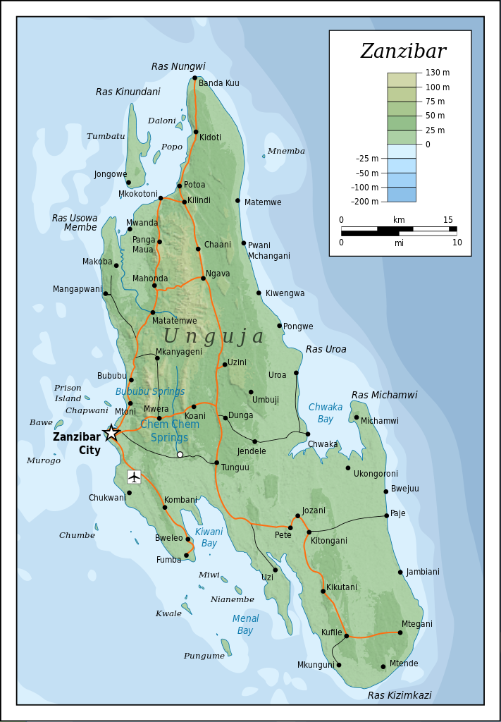
Self-made in Inkscape (renamed from Image:Topographic map of Zanzibar.svg). Roads, rivers and place names based on a public domain 1976 CIA map (from http://www.lib.utexas.edu/maps/tanzania.html) with some updates applied. Topography based on public domain SRTM data from NASA. Bathymetry per http://www.theissresearch.org/zanzibar/. |
| Munyori | Mysid |
| Other versions |
[]
|


|
This SVG file contains embedded text that can be translated into your language, using any capable SVG editor, text editor or the SVG Translate tool. For more information see: About translating SVG files. |
Kurezinesa
I, the copyright holder of this work, hereby publish it under the following licenses:

|
Permission is granted to copy, distribute and/or modify this document under the terms of the GNU Free Documentation License, Version 1.2 or any later version published by the Free Software Foundation; with no Invariant Sections, no Front-Cover Texts, and no Back-Cover Texts. A copy of the license is included in the section entitled GNU Free Documentation License. |
This file is licensed under the Creative Commons Attribution-Share Alike 4.0 International, 3.0 Unported, 2.5 Generic, 2.0 Generic and 1.0 Generic license.
- Wakasungunuka:
- kugova – kucheza, kugovera ne kutumira basa
- kurhimikisa – kugadzirisa basa
- Pasi pemamiriro anotevera:
- Uzikano – Unofanhira kupa kiredhiti yakakodzeka, ipa kochekero yekune rezinesi, uye ratidza kana zvichinjirudzo zvaitwa. Ita sokudaro zviichienderana nenzira inonzwisisika, asi kwete nenzira ingaratidze zvekudii kuti murezinesi anokutsigira kana kushandiso kwako.
- gova saizvo – If you remix, transform, or build upon the material, you must distribute your contributions under the same or compatible license as the original.
Unokwanisa kusarura rezinesi inoenderana nezvaunoda.
Nhoroondo ye fayera
Dzvanya pa musi/nguva kuti uringe fayera sekuoneka kwaraita panguva iyoyo.
| Musi/Nguva | Mfananoudoko | Mitandu | Mushandisi | Komenda | |
|---|---|---|---|---|---|
| parizvino | 20:52, 20 Chikunguru 2010 | | 420 × 605 (409 KB) | Mysid | cropping fail! |
| 20:50, 20 Chikunguru 2010 |  | 429 × 630 (409 KB) | Mysid | revised with relief shading and higher-grain topography | |
| 11:01, 19 Kubvumbi 2008 |  | 400 × 601 (61 KB) | Bibi Saint-Pol | {{inkscape}} == {{int:filedesc}} == {{Information |Description= {{en|Topographic map of Zanzibar, Tanzania.}} {{fi|Sansibarin (Tansania) topografinen kartta.}} |Source=Self-made in Inkscape.<br/>Boundaries based on a public domain 1976 CIA map (from http: |
Kushandiswa kwe fayera
The following page uses this file:
Kushandiswa kwe fayera pasirose
Mawiki anotevera ayo anoshandisa fayera iri:
- Hushandiso pa af.wikipedia.org
- Hushandiso pa ar.wikipedia.org
- Hushandiso pa bg.wikipedia.org
- Hushandiso pa ca.wikipedia.org
- Hushandiso pa ceb.wikipedia.org
- Hushandiso pa cs.wikipedia.org
- Hushandiso pa cy.wikipedia.org
- Hushandiso pa da.wikipedia.org
- Hushandiso pa de.wikipedia.org
- Hushandiso pa de.wikivoyage.org
- Hushandiso pa el.wikipedia.org
- Hushandiso pa en.wikipedia.org
- Hushandiso pa eo.wikipedia.org
- Hushandiso pa es.wikipedia.org
- Hushandiso pa eu.wikipedia.org
- Hushandiso pa fr.wikipedia.org
- Hushandiso pa fy.wikipedia.org
- Hushandiso pa gl.wikipedia.org
- Hushandiso pa he.wikipedia.org
- Hushandiso pa hr.wikipedia.org
- Hushandiso pa hy.wikipedia.org
- Hushandiso pa id.wikipedia.org
- Hushandiso pa it.wikivoyage.org
- Hushandiso pa ko.wikipedia.org
- Hushandiso pa lt.wikipedia.org
- Hushandiso pa mrj.wikipedia.org
- Hushandiso pa nl.wikipedia.org
- Hushandiso pa no.wikipedia.org
- Hushandiso pa pl.wikipedia.org
- Hushandiso pa pl.wiktionary.org
- Hushandiso pa ru.wikipedia.org
- Hushandiso pa sh.wikipedia.org
- Hushandiso pa sq.wikipedia.org
- Hushandiso pa sv.wikipedia.org
- Hushandiso pa uk.wikipedia.org
- Hushandiso pa ur.wikipedia.org
- Hushandiso pa vi.wikipedia.org
Ringa kushandiswa kumwe kwe vupasirose kwe fayera rino.