
File:Satsunan-Islands-Kagoshima-Japan.png

Kukura kwe chipandwa ichi: 391 × 599 pixels Zvimwe misimbiro: 157 × 240 pixels | 313 × 480 pixels | 501 × 768 pixels | 668 × 1,024 pixels | 1,622 × 2,484 pixels
Fayera repachivambo (1,622 × 2,484 pixels, file size: 1.24 MB, MIME type: image/png)
Muchipfupiso
| Mutsananguro |
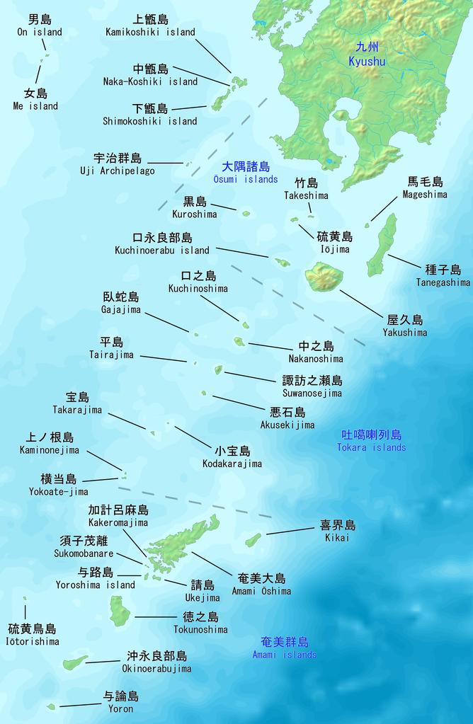
English: Map of the Satsunan Islands of Kagoshima, Japan. Made with DEMIS World Map Server.
日本語: 薩南諸島の地図。 鹿児島、日本。 |
||||
| Musi | |||||
| Mabviro | https://www.demis.nl/products/web-map-server/examples | ||||
| Munyori |
DEMIS World Map Server, Artanisen
|
Kurezinesa
| This file is made available under the Creative Commons CC0 1.0 Universal Public Domain Dedication. | |
| The person who associated a work with this deed has dedicated the work to the public domain by waiving all of their rights to the work worldwide under copyright law, including all related and neighboring rights, to the extent allowed by law. You can copy, modify, distribute and perform the work, even for commercial purposes, all without asking permission.
|
Nhoroondo ye fayera
Dzvanya pa musi/nguva kuti uringe fayera sekuoneka kwaraita panguva iyoyo.
| Musi/Nguva | Mfananoudoko | Mitandu | Mushandisi | Komenda | |
|---|---|---|---|---|---|
| parizvino | 20:04, 22 Gumiguru 2019 | | 1,622 × 2,484 (1.24 MB) | Artanisen | Added Sukomobanare island (須子茂離島). |
| 05:09, 21 Gumiguru 2019 |  | 1,622 × 2,484 (1.22 MB) | Artanisen | Added info about the Tokara islands, Amami islands and Osumi islands. | |
| 20:23, 20 Gumiguru 2019 |  | 1,622 × 2,484 (1.15 MB) | Artanisen | User created page with UploadWizard |
Kushandiswa kwe fayera
The following page uses this file:
Kushandiswa kwe fayera pasirose
Mawiki anotevera ayo anoshandisa fayera iri:
- Hushandiso pa ar.wikipedia.org
- Hushandiso pa az.wikipedia.org
- Hushandiso pa bg.wikipedia.org
- Hushandiso pa bn.wikipedia.org
- Hushandiso pa ca.wikipedia.org
- Hushandiso pa ceb.wikipedia.org
- Hushandiso pa cs.wikipedia.org
- Hushandiso pa de.wikipedia.org
- Hushandiso pa en.wikipedia.org
- Hushandiso pa es.wikipedia.org
- Hushandiso pa fa.wikipedia.org
- Hushandiso pa fr.wikipedia.org
- Hushandiso pa gl.wikipedia.org
- Hushandiso pa id.wikipedia.org
- Hushandiso pa it.wikipedia.org
- Hushandiso pa ja.wikipedia.org
Ringa kushandiswa kumwe kwe vupasirose kwe fayera rino.