
File:Morina ruins.jpg

Kukura kwe chipandwa ichi: 800 × 538 pixels Zvimwe misimbiro: 320 × 215 pixels | 640 × 431 pixels | 1,024 × 689 pixels | 1,280 × 862 pixels | 2,560 × 1,723 pixels | 5,246 × 3,531 pixels
Fayera repachivambo (5,246 × 3,531 pixels, file size: 12.93 MB, MIME type: image/jpeg)
Muchipfupiso
| Mutsananguro |
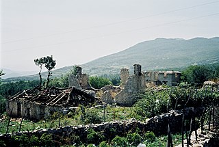
English: Ruins near Morina in the White Drin valley, at the border between Albania and Kosovo. A nearby village is called Planeja, the mountain to the right is called Pastrik. Taken in summer 2001 from a KFOR tank.
These buildings may have been destroyed in the attack, mentioned in the following quote: FOREIGN & COMMONWEALTH OFFICE, LONDON, JUNE 1999 23-24 May |
||
| Musi | |||
| Mabviro | Basa rangu | ||
| Munyori |
|
| Camera location | | View this and other nearby images on: OpenStreetMap |
|---|
I, the copyright holder of this work, hereby publish it under the following licenses:

|
Permission is granted to copy, distribute and/or modify this document under the terms of the GNU Free Documentation License, Version 1.2 or any later version published by the Free Software Foundation; with no Invariant Sections, no Front-Cover Texts, and no Back-Cover Texts. A copy of the license is included in the section entitled GNU Free Documentation License. |
This file is licensed under the Creative Commons Attribution 3.0 Unported license.
- Wakasungunuka:
- kugova – kucheza, kugovera ne kutumira basa
- kurhimikisa – kugadzirisa basa
- Pasi pemamiriro anotevera:
- Uzikano – Unofanhira kupa kiredhiti yakakodzeka, ipa kochekero yekune rezinesi, uye ratidza kana zvichinjirudzo zvaitwa. Ita sokudaro zviichienderana nenzira inonzwisisika, asi kwete nenzira ingaratidze zvekudii kuti murezinesi anokutsigira kana kushandiso kwako.
Unokwanisa kusarura rezinesi inoenderana nezvaunoda.
Nhoroondo ye fayera
Dzvanya pa musi/nguva kuti uringe fayera sekuoneka kwaraita panguva iyoyo.
| Musi/Nguva | Mfananoudoko | Mitandu | Mushandisi | Komenda | |
|---|---|---|---|---|---|
| parizvino | 14:11, 7 Kurume 2010 | | 5,246 × 3,531 (12.93 MB) | Watchduck | Reverted to version as of 16:04, 13 December 2009 |
| 20:48, 14 Zvita 2009 |  | 5,163 × 3,431 (12.44 MB) | Watchduck | color correction | |
| 16:04, 13 Zvita 2009 |  | 5,246 × 3,531 (12.93 MB) | Watchduck | There was a black border rest on the left side. | |
| 15:57, 13 Zvita 2009 |  | 5,258 × 3,531 (12.45 MB) | Watchduck | {{Information |Description={{en|1=Ruins near Morina in the White Drin valley, at the border between Albania and Kosovo. Taken in summer 2001 from a KFOR tank.}} |Source={{own}} |Author=[[U |
Kushandiswa kwe fayera
There are no pages that use this file.
Kushandiswa kwe fayera pasirose
Mawiki anotevera ayo anoshandisa fayera iri:
- Hushandiso pa cs.wikipedia.org
- Hushandiso pa de.wikipedia.org
- Hushandiso pa en.wikipedia.org
- Hushandiso pa en.wikiversity.org
- Hushandiso pa fr.wikipedia.org
- Hushandiso pa id.wikipedia.org
- Hushandiso pa pl.wikipedia.org
- Hushandiso pa pt.wikipedia.org
- Hushandiso pa ru.wikipedia.org
- Hushandiso pa sh.wikipedia.org
- Hushandiso pa sq.wikipedia.org
- Hushandiso pa sr.wikipedia.org
- Hushandiso pa te.wiktionary.org
- Hushandiso pa www.wikidata.org
- Hushandiso pa zh.wikipedia.org