
File:Matabeleland.svg

Size of this PNG preview of this SVG file: 250 × 228 pixels. Zvimwe misimbiro: 263 × 240 pixels | 526 × 480 pixels | 842 × 768 pixels | 1,123 × 1,024 pixels | 2,246 × 2,048 pixels
Fayera repachivambo (SVG file, nominally 250 × 228 pixels, file size: 30 KB)
Muchipfupiso
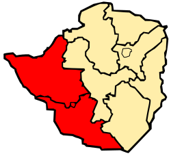
| Mutsananguro | Map of Zimbabwe showing Matabeleland |
| Musi | |
| Mabviro | Basa rangu |
| Munyori | Mangwanani using Inkscape |
Kurezinesa
| I, the copyright holder of this work, release this work into the public domain. This applies worldwide. In some countries this may not be legally possible; if so: I grant anyone the right to use this work for any purpose, without any conditions, unless such conditions are required by law. |
Nhoroondo ye fayera
Dzvanya pa musi/nguva kuti uringe fayera sekuoneka kwaraita panguva iyoyo.
| Musi/Nguva | Mfananoudoko | Mitandu | Mushandisi | Komenda | |
|---|---|---|---|---|---|
| parizvino | 17:26, 4 Kurume 2008 | | 250 × 228 (30 KB) | Mangwanani | == Summary == {{Information |Description=Map of Zimbabwe showing Matabeleland |Source=self made |Date=3 March 2008 |Author=Mangwanani using Inkscape |Permission= |other_versions= }} == Licensing == {{PD-self}} Category:Maps of Zimbabwe |
Kushandiswa kwe fayera
The following page uses this file:
Kushandiswa kwe fayera pasirose
Mawiki anotevera ayo anoshandisa fayera iri:
- Hushandiso pa af.wikipedia.org
- Hushandiso pa be.wikipedia.org
- Hushandiso pa bn.wikipedia.org
- Hushandiso pa en.wikipedia.org
- Hushandiso pa fa.wikipedia.org
- Hushandiso pa fr.wikipedia.org
- Hushandiso pa fr.wiktionary.org
- Hushandiso pa id.wikipedia.org
- Hushandiso pa incubator.wikimedia.org
- Hushandiso pa it.wikipedia.org
- Hushandiso pa it.wikivoyage.org
- Hushandiso pa ko.wikipedia.org
- Hushandiso pa kv.wikipedia.org
- Hushandiso pa lt.wikipedia.org
- Hushandiso pa nl.wikipedia.org
- Hushandiso pa pt.wikipedia.org
- Hushandiso pa ru.wikipedia.org
- Hushandiso pa tr.wikipedia.org
- Hushandiso pa tum.wikipedia.org
- Hushandiso pa uk.wikipedia.org
- Hushandiso pa ur.wikipedia.org
- Hushandiso pa xh.wikipedia.org
- Hushandiso pa zh.wikipedia.org