
File:DOE Devin.jpg

Kukura kwe chipandwa ichi: 800 × 600 pixels Zvimwe misimbiro: 320 × 240 pixels | 640 × 480 pixels | 1,024 × 768 pixels | 1,280 × 960 pixels | 2,560 × 1,920 pixels
Fayera repachivambo (2,560 × 1,920 pixels, file size: 1.16 MB, MIME type: image/jpeg)
| Mutsananguro |
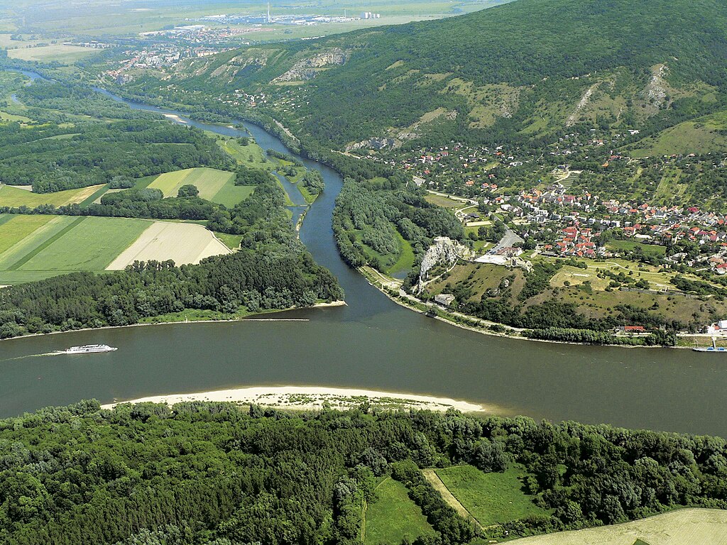
Català: Aiguabarreig dels rius Morava (a dalt) i Danubi (d'esquerra a dreta) a Devín, molt aprop de Bratislava. El Morava abans del conflent i el Danubi després marquen la frontera entre Àustria i Txèquia.
Čeština: Ústí řeky Moravy do Dunaje pod zříceninou devínského hradu. Zde by vodní koridor D-O-L odbočoval v případě že bude zvolena varianta A nebo D.
Deutsch: Zusammenfluss der March und der Donau.
English: The site of the Morava influx into the Danube under the ruins of Devín. The water corridor D-O-E would branch-off here in case of the variant A or D. |
||
| Musi | |||
| Mabviro | Snímek pořízený se soukromého letadla | ||
| Munyori | Jaroslav Kubec | ||
| Mvumo (Kushandisazve fayera) |
I, the copyright holder of this work, hereby publish it under the following licenses:
This file is licensed under the Creative Commons Attribution 3.0 Unported license.
Unokwanisa kusarura rezinesi inoenderana nezvaunoda. |

| Object location | | View this and other nearby images on: OpenStreetMap |
|---|
Nhoroondo ye fayera
Dzvanya pa musi/nguva kuti uringe fayera sekuoneka kwaraita panguva iyoyo.
| Musi/Nguva | Mfananoudoko | Mitandu | Mushandisi | Komenda | |
|---|---|---|---|---|---|
| parizvino | 14:29, 3 Zvita 2008 | | 2,560 × 1,920 (1.16 MB) | Kocour86 | {{Information |Description={{en|1=The site of the Morava influx into the Danube under the ruins of Devín. The water corridor D-O-E would branch-off here in case of the variant A or D.}} {{cs|1=Ústí řeky Moravy do Dunaje pod zříceninou devínského h |
Kushandiswa kwe fayera
The following page uses this file:
Kushandiswa kwe fayera pasirose
Mawiki anotevera ayo anoshandisa fayera iri:
- Hushandiso pa be-tarask.wikipedia.org
- Hushandiso pa bg.wikipedia.org
- Hushandiso pa ca.wikipedia.org
- Hushandiso pa cs.wikipedia.org
- Hushandiso pa de.wikipedia.org
- Hushandiso pa de.wikivoyage.org
- Hushandiso pa en.wikipedia.org
- Hushandiso pa en.wiktionary.org
- Hushandiso pa eo.wikipedia.org
- Hushandiso pa es.wikipedia.org
- Hushandiso pa fr.wikipedia.org
- Hushandiso pa he.wikipedia.org
- Hushandiso pa hu.wikipedia.org
- Hushandiso pa kk.wikipedia.org
- Hushandiso pa ku.wikipedia.org
- Hushandiso pa nl.wikivoyage.org
- Hushandiso pa no.wikipedia.org
- Hushandiso pa pl.wikipedia.org
- Hushandiso pa ro.wikipedia.org
- Hushandiso pa ro.wiktionary.org
- Hushandiso pa ru.wikipedia.org
- Hushandiso pa sk.wikipedia.org
- Hushandiso pa sl.wikipedia.org
- Hushandiso pa sr.wikipedia.org
- Википедија:Акција поводом Дана Дунава
- Разговор:Јантра (река)
- Разговор:Осам (река)
- Разговор:Илз (река)
- Разговор:Национални парк Летеа
- Разговор:Реген (река)
- Разговор:Мост Лафранкони
- Разговор:Мост СНП
- Разговор:Камени мост (Регенсбург)
- Разговор:Дан Дунава
- Разговор:Стари мост (Братислава)
- Разговор:Мост Аполо
- Разговор:Резерват биосфере Мура-Драва-Дунав
- Разговор:Дан европског Амазона
- Разговор:Мост Марије Валерије
Ringa kushandiswa kumwe kwe vupasirose kwe fayera rino.