
File:Gwayi Basin OSM.svg

Size of this PNG preview of this SVG file: 567 × 425 pixels. Zvimwe misimbiro: 320 × 240 pixels | 640 × 480 pixels | 1,024 × 768 pixels | 1,280 × 959 pixels | 2,560 × 1,919 pixels
Fayera repachivambo (SVG file, nominally 567 × 425 pixels, file size: 2.19 MB)
Muchipfupiso
| Mutsananguro |
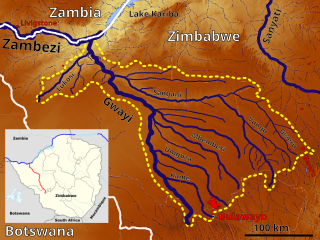
English: The Gwayi Basin OSM, Based up on US Army map SE35 |
| Musi | |
| Mabviro | https://maps-for-free.com, http://legacy.lib.utexas.edu/maps/ams/africa_1m/, Location map:File:Zimbabwe adm location map.svg |
| Munyori | Hans Braxmeier & Peter in s, Location map:NordNordWest |
This file is licensed under the Creative Commons Attribution-Share Alike 3.0 Unported license.
- Wakasungunuka:
- kugova – kucheza, kugovera ne kutumira basa
- kurhimikisa – kugadzirisa basa
- Pasi pemamiriro anotevera:
- Uzikano – Unofanhira kupa kiredhiti yakakodzeka, ipa kochekero yekune rezinesi, uye ratidza kana zvichinjirudzo zvaitwa. Ita sokudaro zviichienderana nenzira inonzwisisika, asi kwete nenzira ingaratidze zvekudii kuti murezinesi anokutsigira kana kushandiso kwako.
- gova saizvo – If you remix, transform, or build upon the material, you must distribute your contributions under the same or compatible license as the original.
Nhoroondo ye fayera
Dzvanya pa musi/nguva kuti uringe fayera sekuoneka kwaraita panguva iyoyo.
| Musi/Nguva | Mfananoudoko | Mitandu | Mushandisi | Komenda | |
|---|---|---|---|---|---|
| parizvino | 11:43, 30 Chivabvu 2022 | | 567 × 425 (2.19 MB) | Peter in s | Kontrast, Lokation,... |
| 12:31, 6 Gunyana 2019 |  | 567 × 425 (2.16 MB) | Peter in s | {{Information |description ={{en|1=The Gwayi Basin OSM}} |date =2019-09-06 |source =https://maps-for-free.com/ |author =Hans Braxmeier & Peter in s }} {{cc-by-sa-2.0}} Category:Maps of rivers of Zimbabwe Category:Drainage basin maps of Africa |
Kushandiswa kwe fayera
The following page uses this file:
Kushandiswa kwe fayera pasirose
Mawiki anotevera ayo anoshandisa fayera iri:
- Hushandiso pa af.wikipedia.org
- Hushandiso pa de.wikipedia.org
- Hushandiso pa en.wikipedia.org
- Hushandiso pa ff.wikipedia.org
- Hushandiso pa fr.wikipedia.org
- Hushandiso pa ha.wikipedia.org